
The Saku public-data pilot
Saku valla olukorrapilt — a decision-support awareness dashboard and common operating picture demonstrator, built on public data.
What it is
The question it answers, for the people who sit in a municipal crisis committee: which settlements, layers and official warnings are relevant right now, where does each fact come from, and how fresh is it.
It is not a digital twin, not an early-warning system, not real-time, and not AI. Those four descriptions are wrong about it and will stay wrong about it.
What it looks like
Two screenshots from the running workspace. Access is by invitation, so these are what a signed-in municipal user sees: the same values, the same data-class chips and the same retrieval times that the pages themselves carry.
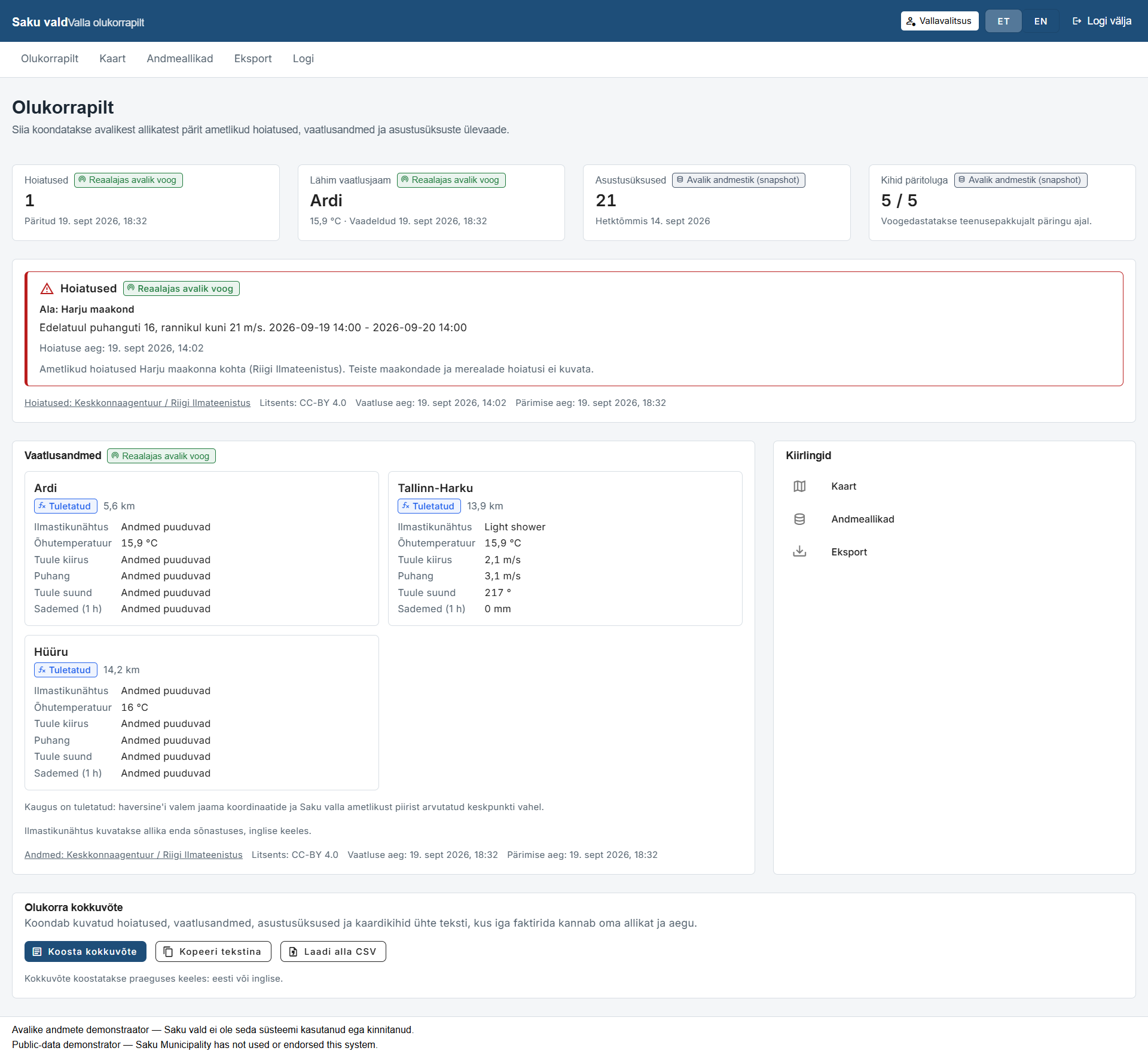
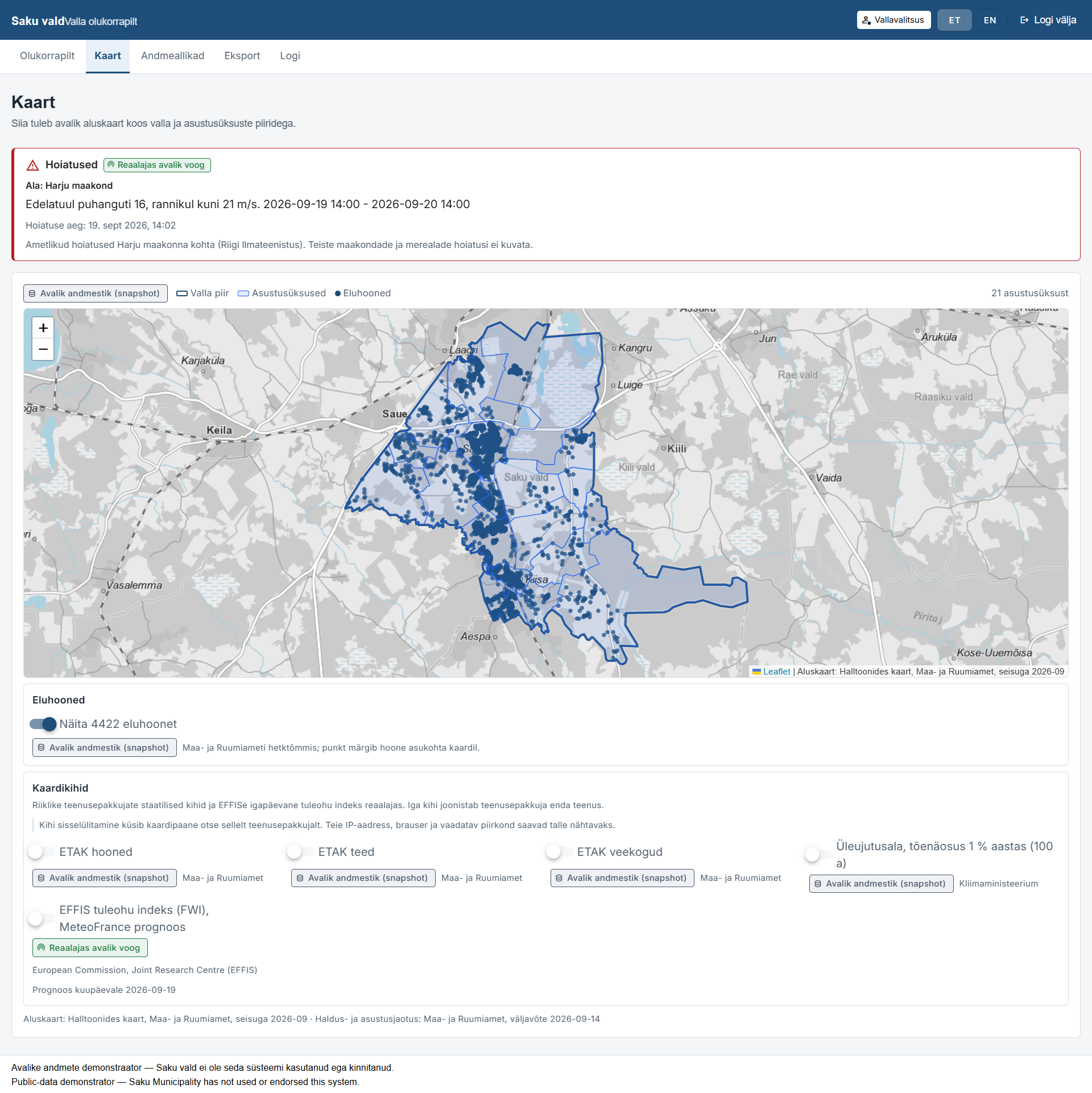
Data sources
Every provider, dataset and licence the workspace is built on, with the status of each one. Nothing outside this list is used.
| Provider | Dataset | Licence | Data class | Status |
|---|---|---|---|---|
| Riigi Ilmateenistus / Keskkonnaagentuur | Official weather warnings in force for Harju maakond | Keskkonnaagentuur attribution | LIVE | Available now |
| Riigi Ilmateenistus / Keskkonnaagentuur | Observations from the nearest national stations | Keskkonnaagentuur attribution | LIVE | Available now |
| Maa- ja Ruumiamet | Administrative units — the Saku boundary and its settlements | Maa- ja Ruumiamet open-data licence / CC BY 4.0-equivalent with attribution | STATIC | Available now |
| Maa- ja Ruumiamet | ETAK layers and the national base map | Maa- ja Ruumiamet open-data licence / CC BY 4.0-equivalent with attribution | STATIC | Available now |
| Copernicus EFFIS | Fire-weather index for the current day | EFFIS terms | LIVE | Available now |
| Statistikaamet | Population grid, 1 × 1 km | Statistikaamet open-data terms with attribution | DERIVED | Available now |
What it deliberately does not include
These exclusions are decisions, not gaps waiting to be closed. Each one has a reason, and the reason is stated.
- No power-outage status. Elektrilevi's outage map has no confirmed open licence, so it is linked rather than integrated.
- No hazardous-establishment danger zones and no shelter locations. The right to republish them is unconfirmed, so Päästeamet is linked instead.
- No Saku municipal contacts, assets, plans or crisis-committee documents. These would require Saku's permission, and none has been requested.
- No hazard forecast, no damage estimate, no building-level risk score and no scenario engine for Saku. The demonstrator's uncalibrated engines are not reused here.
- No sensors, no citizen data, and no alert dispatch of any kind.
- Earthquake does not appear at all, because Estonia is a very low seismicity region.
Access
Access is by invitation. Every Saku page and every Saku endpoint requires a sign-in, a role and a matching project; accounts are provisioned by Hubbcast and there is no self-service registration.
Disclaimer
Saku Municipality has not used, validated or endorsed this workspace, and nothing here is a municipal record. No data has been requested from Saku or from any other institution. Every layer comes from a public source that is named, licensed and time-stamped on screen.
Weather observations come from the nearest national stations and not from sensors in Saku, and official warnings are issued at county level for Harju maakond rather than for the municipality.